The US Government Is Underfunding Flood Warning Systems

Despite the rising threat of climate disasters like last week’s deadly flash flood in Texas, US lawmakers continue to underfund the federal government program supporting a nationwide flood warning system.

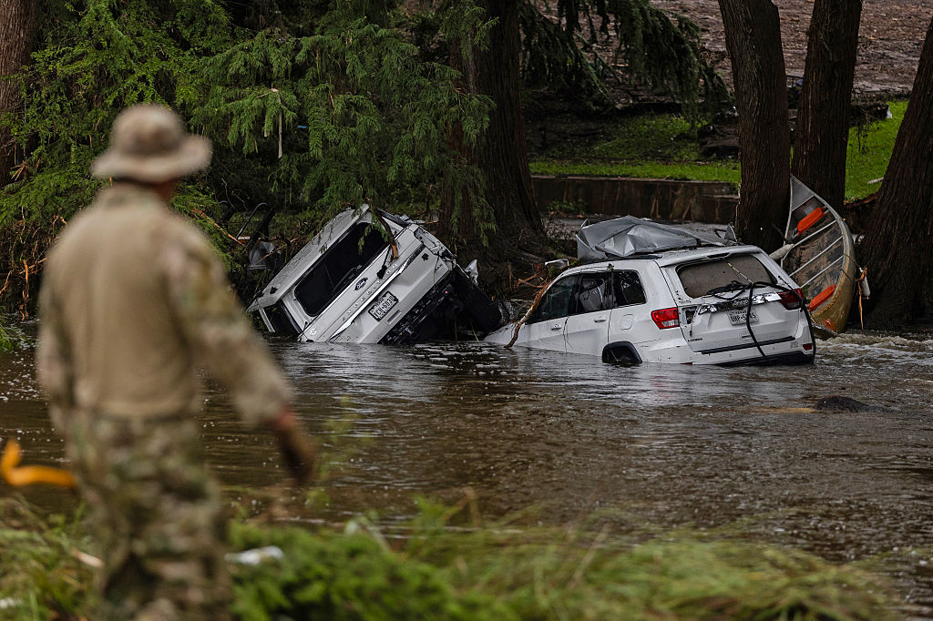
Vehicles sit submerged as a search-and-rescue worker looks through debris for any survivors or remains of people swept up in the flash flooding on July 6, 2025, in Hunt, Texas. (Jim Vondruska / Getty Images)

Despite the rising threat of climate disasters like last week’s deadly flash flood in Texas, the vast majority of America’s waterways are still not being monitored by water level gauges that help identify impending disasters. Lawmakers have long declined to fully fund the federal government’s program supporting a nationwide flood warning system, according to government documents reviewed by the Lever.

While demanding billions of dollars of new tax cuts in the months before the Texas disaster, President Donald Trump’s administration proposed to nearly halve the budget of the federal agency overseeing a federal flood warning network — and proposed a 22 percent cut to the specific budget line funding that system. During Trump’s first term, the number of water level gauges declined for the first time since Congress upgraded the program nearly twenty years ago.

As a result, 99 percent of America’s waterways are not currently monitored by such systems. In all, more than 1,300 sites deemed a federal priority to “provide critical data for flood warnings” do not have the gauges “because of funding limitations,” according to a 2024 report from the United States Geological Survey (USGS), which oversees federal funding for the gauges.

Dozens of these devices, called streamgages, have been discontinued nationwide in the past four years, experts wrote to lawmakers in February. According to federal data, hundreds more of the meters, which continuously measure and report water levels, are in jeopardy of going offline without more funding to manage these instruments.

The Interstate Council on Water Policy, a water resource management group, has been urging Congress since at least 2014 to increase funding for the Federal Priority Streamgage program, a consortium of federal water monitoring stations that track water levels nationwide. These groups are asking for just $33 million in funding for the federal program.

“Our organizations rely heavily upon the information provided by these streamgages to make critical decisions about public safety, respond to extreme weather events, forecast and maintain water supplies, and support the nation’s economy,” a coalition of civil engineering, water management, and water safety organizations wrote to lawmakers months before the Texas flood. “Any further funding shortfalls will greatly impact our ability to protect public safety, support infrastructure and plan for and respond to extreme weather events.”

More Disasters, Fewer Gages

In 2009, Congress passed the SECURE Water Act to vastly expand the streamgage network. But after an initial infusion of funding to begin covering 4,700 locations, the funding plateaued during Trump’s first term, and the number of sites funded by the federal government declined for the first time since the legislation was enacted, according to data compiled by the Congressional Research Service.

During Trump’s first term, the program funding did not meet the SECURE Water Act’s mandate for an entirely federally funded suite of at least 4,700 streamgage sites.

“Funding decreased when accounting for inflation,” reported the nonpartisan Congressional Research Service, which warned lawmakers that with costs increasing by up to 3 percent a year, the funding “may not be sufficient to maintain the current operations” of the system and could lead agencies “to discontinue some [Federal Priority Streamgage program] streamgages.”

The same report warned that the “USGS estimates that $130 million in additional funding for capital costs would be needed to complete and harden the network (of gages); however, an average of only about $25 million was appropriated annually for (the network) between FY2014 and FY2021, resulting in no expansion of the network to complete the designated network.”

The needed funds for this program are a part of $3.7 trillion in additional funding needed to address the country’s ailing infrastructure, said Tom Smith, executive director of the American Society of Civil Engineers.

“We’re seeing more and more extreme weather events, whether it’s wind or tornado or snow loads or rain or tsunami or floods, we are seeing more extreme conditions that we need to be prepared for,” Smith told the Lever. “And so the more data that we have, the better decisions we can make in anticipating future conditions.”

The Congressional Research Service reached a similar conclusion in a 2021 report, stating that “without adequate information, some observers contend that engineers may overdesign structures, resulting in greater costs, or may not make proper allowances for floods, compromising public safety.”

As the country struggles to provide real-time information to residents in flood-prone areas, in recent months, the Trump administration gutted restrictions on building in flood zones and fired hundreds of staffers at the Federal Emergency Management Agency, the agency tasked with providing funds and emergency response during disasters. The president also gutted the National Oceanic and Atmospheric Administration, a federal agency tasked with weather forecasting and which oversees the National Weather Service. More than one thousand staffers were either fired or left the agency since the beginning of this year, resulting in a 20 percent reduction in staff.

High and Dry

States and municipalities like Kerr County, Texas — a flood-prone area known as Flash Flood Alley — have scrambled to fund existing streamgages and install new ones as federal funding for such projects has remained stagnant in past decades.

Local officials in Kerr County considered implementing stream monitoring devices and warning sirens after floods in 2015 and 2017. However, county officials voted against installing such devices, citing high costs with one official stating that the system would be “a little extravagant for Kerr County, with sirens and such.”

Over the Fourth of July weekend, floods swept through the area, killing more than one hundred people, including more than two dozen children at a summer camp. Three monitoring sites on small tributaries upstream of the flooded area showed water level spikes before flood waters hit. But local warning systems weren’t enough, and local officials used a word-of-mouth system with residents upstream calling downstream residents, warning of potential flooding, the New York Times reported.

Texas currently has at least six streamgages currently in danger of being discontinued as funding for their operation remains uncertain — despite the state’s commitment to its flood infrastructure program.

Hundreds of other streamgages around the country are facing similar risks, while seventeen streamgages were discontinued in 2024 alone thanks to budget shortfalls, according to data from the US Geological Survey’s Groundwater and Streamflow Information Program. Near Asheville, North Carolina, which was ravaged by flooding from Hurricane Helene in September 2024, four gauges are currently at risk of losing their funding. Fourteen gauges across flood-prone areas of Florida are also currently at risk of going offline.

According to experts, discontinuing streamgages not only hinders emergency response networks, but also prevents the collection of irreplaceable long-term data that scientists use to track water resources and to prevent future crises. This information is integral to the construction of critical infrastructure like bridges, water treatment plants, and hydroelectric dams.

These devices are “super critical for lifesaving alerts for river flooding specifically,” said Julie Arbit, a research specialist for the Center for Social Solutions at the University of Michigan. Arbit added that these types of devices aren’t intended to monitor smaller tributaries that are more prone to flash floods, but the technology is evolving.

“Monitoring tributaries would also help predictions for the larger rivers,” Arbit told the Lever. “There are 90,000-plus small tributary basins in the US, so it’s a complex problem. Less complex when you only consider regions we know have flash flooding.”

However, less than 1 percent of waterways are currently monitored by streamgages, according to the USGS. A single sensor can cost more than $25,000 and requires continual operational expenses, like routine calibration to account for changing streambeds and shifting flow patterns, often in remote and challenging environments, to maintain accurate readings. Nearly 70 percent of that cost may fall on communities, which represents a particular burden on small and urban watersheds prone to flash floods.

Scientists have warned for years that faster, widespread, and more intense flooding is growing increasingly common as the climate changes, affecting not just coastal areas but riverine locations as well, and the government has acknowledged that these risks threaten communities across the United States.

But Congress has been dragging its feet on building out a federally funded “backbone” network of streamflow gauges across the United States, as part of a plan that was originally mandated by lawmakers in 1999.

A 2022 assessment of the Federal Priority Streamgage program found that the partial funding, largely cobbled together between direct appropriations to the Federal Priority Streamgage program via the USGS and the Cooperative Matching Funds program, covers just 1,430 gages out of 4,758 eligible streamflow-gage locations, roughly a third of all locations, and doesn’t offer more funding to build new monitoring stations.

In the aftermath of the Texas flood, a Kerr County official told the New York Times that flood warning systems are cost prohibitive for small communities — which is a problem that the Federal Priority Streamgage program was designed to combat. In the 1990s, the federal government split 50 percent of the cost to implement streamgages with local municipalities, but because of inflation by 2020 localities were responsible for nearly 70 percent of the costs, according to a 2021 report from the Congressional Research Service.

“The lack of federal funding for [streamgage] sites increasingly places the burden on state, regional and local entities to assume the costs for maintenance and operation,” said Beth Callaway, executive director of the Interstate Council on Water Policy, a water resource management group. “As more states and local communities find it increasingly difficult to make up for the gap . . . we are seeing an increased rate of loss of sites and long-term data that cannot be re-created.”

Last year, the Federal Priority Streamgage program was reauthorized to maintain its current funding of $26 million through 2028. A coalition of 105 water management experts claimed in a February 27 letter that this amount is already inadequate, instead calling for $7.3 million more to “halt funding shortfalls that are leading to the elimination of critical streamgages.”

Experts claim that states and local communities find it increasingly difficult to make up for the operational gap in funding streamgage costs due to their own local economic pressures and inflation. But instead of budget increases, the Federal Priority Streamgage program could soon face further cuts.

Trump’s fiscal year 2026 budget allocates $891.6 million to the USGS, about 39 percent less than the 2025 annual appropriation of $1.45 billion. The budget furthermore “eliminates programs that provide grants to universities, duplicate other Federal research programs and focus on social agendas (e.g., climate change).”

The budget instead directs the USGS to “focus on achieving dominance in energy and critical minerals” as well as supporting “artificial intelligence and machine-learning approaches for USGS’s water models and assessments.”

The administration’s budget proposes a 22 percent cut to the USGS’s water resources programs, which funds the Groundwater and Streamflow Information Program, which oversees the streamgage program. The proposal does not detail how the White House wants that cut implemented across specific programs — but the administration asserts that despite the cuts, it “maintains support for USGS streamgages.”

Trump’s General Services Administration, an agency tasked with managing federal property, has also proposed the closure of regional USGS offices across the country, which experts say will complicate technicians’ efforts to visit streamgage sites in remote locations, house sensitive equipment, or maintain research materials.

The cuts come as funding for the streamgage network has remained stagnant for more than five years, Callaway said.

“Full implementation of the network is estimated at $130 million, and it has never been funded at that level,” Callaway told the Lever. “Funding shortfalls mean that [streamgage] sites are increasingly at risk of being discontinued. That spells a loss of important information that is used to protect life, property, and reduce risk. The functions that streamgages provide are not academic luxuries; they are foundational tools for protecting life, property, drinking water, agriculture, and biodiversity.”