Colombia’s Receding Coastline
In Colombia, coastal erosion caused by a combination of climate change and environmentally destructive industrial agriculture is displacing the country’s poorest citizens. But the scale of the disaster means that it has no easy solutions.
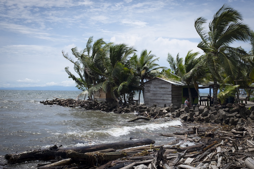
Colombia’s coastline on the Gulf of Urabá. (Kurt Hollander / Jacobin)
A coastline is the interface between the land and the sea, and there the land is always in flux, subject to oceans’ and rivers’ constant ebb and flow. In the near future, due to global warming, the sea level will rise at an accelerated pace, leading to more extreme weather conditions for coastal land, including heavier rainfall, flooding, earthquakes, hurricanes, and typhoons. All of these extreme weather conditions will speed up the erosion of coastal land, a phenomenon that represents a very serious threat to life and property in Colombia.
In Colombia, nearly 8 percent of the population live on or near the coast, and thus any alteration to the coastline directly affects millions of people. On the Caribbean coast, where erosion is the greatest, the earth is being lost to the sea at a frightening clip. In the past few decades, popular beaches have been swept away, small towns have been swallowed up by the sea, and hundreds of families have been forced to flee inland.
Beaches along the Caribbean coast of Colombia have suffered the most dramatic effects of erosion, and many of the most popular white sand beaches of the twentieth century no longer exist. The disappearance of beaches is tragic, but it is only one step in the relentless advance of erosion. With the disappearance of beaches, which provide a natural buffer zone and keep waves from directly impacting the land, inland areas start to crumble.
Due to this widespread, fast-acting erosion, the largest economies on the coast, such as tourism, cattle ranching, and the agro-industries of the region (bananas, palm oil, rubber), have also been affected. At the same time, however, these profitable industries are all part of the problem.
On the Caribbean coast, erosion is caused by global climate events, such as rising sea level that produce larger waves. On the Gulf of Urabá, which curves inland from the Caribbean on the western edge of Colombia next to Panama, however, human factors are mostly to blame for the fact that the sea is encroaching upon the land. Cattle ranches, agro-industry, tourism, and residential expansion all debilitate the earth and speed up the natural forces of erosion of the coast.
Mangroves and forests are natural biological systems that, among other functions, provide resilience to coastal land. When these are destroyed to make room for agro-industries or cattle grazing, the topsoil, without tree roots to anchor it to the ground below, is more easily washed away during flooding or heavy rains. When resold and converted into residential or tourist developments, the land tends to settle under the weight of constructions and becomes even more vulnerable. The erosion process is sped up when sand from beaches is collected to mix into concrete that is used to build new constructions on the edge of the sea, leading to the disappearance of the very beaches that made it attractive to build there in the first place.
Fighting a Losing Battle
In Punta Arboletes, a beach destination located at the point where the Caribbean Sea and the Gulf of Urabá meet, the ocean has managed to chew away five miles of coastline over the past half century. This loss of prime beachfront property is best illustrated by two small islands, formerly stretches of sand upon which kids used to play, but now chunks of earth that sit stranded offshore, victims of rising sea levels threatening to engulf the coastal land. Similarly, trees that used to shade restaurants are used by kids as diving platforms several yards out in the sea.
Punta Arboletes is best known as the home of Riviera Del Sol Hotel, a Disney-like palace on the sea. To try to keep its beachfront from washing away, a jetty in the shape of a ship (designed with painted waves, surf boards, totem poles, and Disney characters) was built, but the sea still came in and washed the beach away.
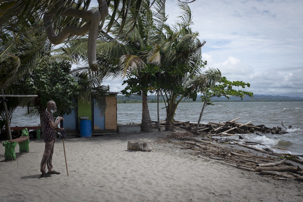
In Necoclí, a small seaside town of only 70,000 inhabitants a bit further south, almost all of the town’s sand beaches have been swallowed up by the sea, and the homes constructed on the street in front of the beaches now have their back doors opening directly onto the gulf. Many of the bars and restaurants that once used the beaches as their outdoor patios for dining and drinking can now only offer a single row of chairs and tables to tourists. Houses built on elevated coastal land now often teeter atop cliffs. The new cemetery in Necoclí, built on the edge of town atop an elevated cliff, will eventually become victim to the erosion of the clay cliffs by the force of the waves and the rising sea level, and the bodies buried there will need to be relocated.
Turbo, a large Afro-Colombian town even further south on the gulf, has been victim to more than twenty-five feet of erosion annually, with a loss of nearly five hundred feet over the past twenty years. Turbo’s former airport, now a naval base, lost the use of its runway due to coastal erosion that was created when the Turbo, Guadlito, and Currulao Rivers were rerouted and the sediment no longer reinforced the land. In addition, the nearly eighty buttresses and rock formations constructed to help protect the city center of Turbo and its beaches increased the force of the waves that batter this outlying area, showing how any protective measures in one area cause problems elsewhere.
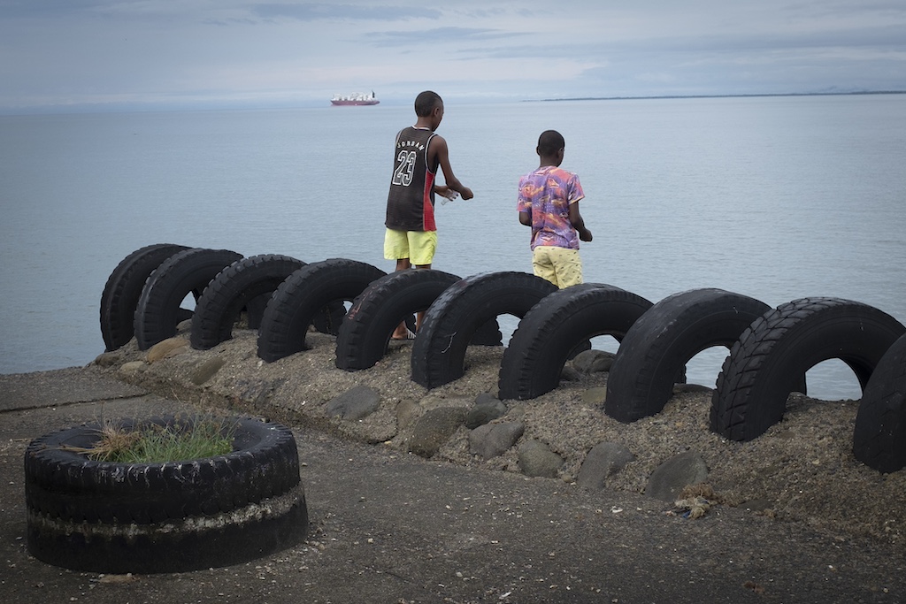
Most of the dozens of breakers and jetties in the towns on the Gulf of Urabá that were designed to protect the towns’ central beaches no longer serve their function and have in fact contributed to the destruction of the coastline both inside and outside the towns. The beaches that still exist, surrounded by rocky embankments parallel to the beach (which look as if they are there to protect against shark attacks), have, due to lack of sand and waves, made the beaches feel more like large swimming pools.
Defensive marine architecture is designed to stem the tide of coastal erosion and to ease the rising sea level. Breakwaters or seawalls made from giant cement blocks (pentapods) and installed parallel to the coastline in the shape of a T or L, and rock jetties built perpendicular to the shore, are used not only to protect beaches but also to stimulate their growth and to replenish the land by aiding in the accumulation of sediments from the rivers’ affluents.
In the long term, however, defensive marine constructions often end up increasing the damage by creating more powerful waves. Anchoring protective constructions to a beach or sandy coastline is difficult and can lead to underwater soil erosion that undermines their foundation and can eventually lead to the erosion of the seafloor itself. The rising sea level, the extraction of sand from the beaches to produce cement, and the construction of large defensive formations anchored to the seabed have all led to the destruction of marine terraces.
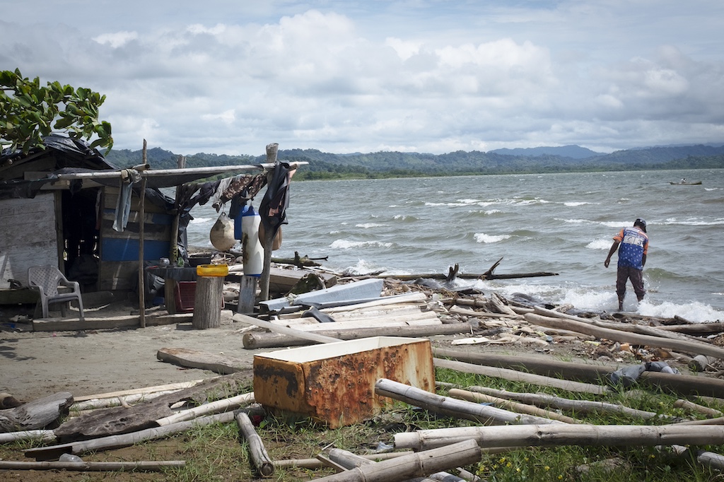
Many homes, hotels, and restaurants in towns on the Gulf of Urabá have used concrete slabs, tires, or geotextile bags filled with sand or cement to keep seawater from entering. Over time, with rising sea levels, most of these bags end up in a watery grave, a sign of the futility of trying to halt the advance of the sea. The retainer walls built to reinforce houses on cliffs where heavy ocean waves break themselves become victims to the force of the ocean and the increasingly rapid crumbling of the land.
Short-term, Shortsighted
Most of the short-term, shortsighted man-made solutions to land erosion on the Gulf of Urabá have failed. Even when they afford temporary relief to the area where they are located, they tend to displace the problems they were designed to fix to surrounding areas. Water, when propelled by powerful geological forces, cannot be stopped by human hands or by any man-made objects. Given enough time, as sea levels constantly rise, all that is solid will eventually turn to mud and melt into the sea.
Invasive water is not the only thing that the Gulf of Urabá suffers from. A chain of hundreds of small “mud volcanos,” first described by the German naturalist Alexander von Humboldt in the nineteenth century, run along the coast. The rising sea level has led to an erosion of great extensions of coastal land and the constant impact of waves has eroded the land’s topsoil and natural terrace, thus uncovering a series of volcanic pits.
Unlike magma or lava volcanos, these mud pits are pressure cookers that contain huge quantities of sediments and organic matter brought in by rivers, and the methane gas produced can lead to small explosions and send mud spilling over into surrounding areas. The expanding waves of mud from these exploding pits can smother cropland and overrun homes, while the explosions can create sinkholes and broken earth that make the land impossible to cultivate or inhabit.
In Arboletes, there are several mud volcanos just outside of town that attract tourists. Most of the coastal land near the volcano is used for cattle grazing and residential homes, the construction of which required cutting down huge swathes of the dense forests. This massive deforestation weakened the soil and made the land particularly vulnerable to erosion. Over time, the rising sea level and the force of the waves washed away the land’s topsoil and uncovered these volcanos. Over the past few years, due to the mud excreted from the deep pits, the beach has become one large mudflat.
The Gulf of Urabá enjoys a privileged location, on the border between South and Central America, connecting by way of the mighty Atrato river the Caribbean Sea with the Pacific Ocean. The region is rich in biodiversity, with an astounding variety of plants, animals, and fish, long providing humans in the area with all the food they need to survive and flourish. As happens so often in Colombia, however, the most far-flung, idyllic locations attract the most violent criminal organizations and armed groups. The Gulf of Urabá has long been an ideal place for drug, arms, and human trafficking.
Surrounded by lush forests and rich soil, crisscrossed by rivers both large and small, the illegal gold mining and timber industry in the region generate immense wealth. The criminal organizations that control the region use the many rivers that flow into the Gulf of Urabá to transport tree trunks from the huge Chocó rainforest. The indiscriminate leveling of trees deep within the forest leads to the littering of beaches all along the coast with unwanted trunks, making swimming nearly impossible. The criminal organizations take the profits from these illegal activities and invest the money into buying up coastal land in and around the gulf. The land, formerly dense jungle, is leveled and then converted into huge cattle ranches and palm oil and banana plantations.
Guerrilla groups (Revolutionary Armed Forces of Colombia or FARC, and Popular Liberation Army or EPL) first came to this far-flung region in the 1960s with the dream of creating a territory independent from the federal government. Up until the ’90s, when several guerrilla groups laid down their arms in peace agreements, armed leftist groups managed to keep out not just the military and government institutions but also the illegal mining and timber industries of the criminal organizations, as well as national and multinational megaprojects, thus protecting the rainforests, rivers, and coastal land from exploitation.
When the guerrillas left or reintegrated into life in the towns, large, well-organized, paramilitary criminal groups took over. Over time, these organizations consolidated their forces into one of the most powerful armed groups in Colombia, the Clan del Golfo, based in and around the Gulf of Urabá, and is responsible for the trafficking of the largest amount of cocaine.
In Necoclí, the hometown of the leader of the Clan del Golfo, as part of a campaign of terror to establish their control in the late 1990s, often with the support of the Colombian army, 130 ex-guerrillas and guerrilla “sympathizers” were murdered, 122 disappeared, and 1,300 families displaced from their land. The same process was carried out in all the towns on the gulf, transforming the region into one of the most violent areas in the country.
Much of the land in the Gulf of Urabá forms part of collective property legally granted in 1993 to people of African and indigenous descent, whose ancestors had long lived in these territories. The Clan del Golfo, nonetheless, in cahoots with local businessmen and government, violently ran black and indigenous communities off of their land. In the last couple of decades, over seventy locals of African descent in Urabá who have tried to claim their land have been murdered.
As elsewhere in Colombia, criminal organizations in the Gulf of Urabá charge protection money (called vaccines), which has stifled local business in the towns and led to a prolonged economic recession, the displacement of inhabitants, and a deterioration of infrastructure. In addition to skimming a percentage of the profits off of all economic activity in the region, the Clan del Golfo managed to strong-arm most of the larger economic actors to make them partners, using their business activity to traffic cocaine and to launder drug money.
Beyond the extortion of and merging with local businesses, the Clan del Golfo successfully and completely infiltrated the local government. While the leftist guerrillas had attempted to create an autonomous economy beyond the reaches of the state, the paramilitary criminal organizations sought to control all aspects of local politics in order to control the local economy.
The situation got to the point where the Clan del Golfo not only ran the local economy, without paying taxes and without any government oversight, they even created a local political party that controlled all aspects of the legal activities of the region. The political party that the Gulf of Urabá created to further their criminal and legal activities in the region began to receive the state and federal funding destined to repair infrastructure, handle garbage collection, run health clinics, and fight against illegal timber poachers and cocaine labs.
By means of their political puppets, the Clan del Golfo also established social organizations and NGOs that purported to aid migrants and the environment. These civil organizations received national and international funding from the United States Agency for International Development (USAID) and the UN Office on Drugs and Crime (UNODC), and one was even awarded an environmental award from the Kellogg Company. The influx of this sizable federal government and international money was in turn used to expand their landownership on the coast and to fund increasingly ambitious illegal operations.
Over time, through violent intimidation, the falsification of signatures on official documents, and murder, the Clan del Golfo gained control over much of the cultivated land and became owners or partners of banana and other large-scale agro-industries. To stifle attempts to unionize workers in the region, and to keep leftist guerrillas out of the region, from 1997 to 2004, Chiquita Brands International, the company that imports most of the bananas to the United States from Colombia, gave almost two million dollars to the Clan del Golfo and supplied them with 3,400 AK-47 rifles and four million rounds of ammunition (even though they were listed by the US State Department as a terrorist organization as early as 2001).
Although they had gained complete control of the politics and economy of a region that was located far from the center of the federal government, allowing them to operate openly, the long arm of the law eventually reached the coast. In 2010, twenty-five politicians from the Gulf of Urabá, all from the same right-wing political party that had been a front for the Clan del Golfo, were arrested for their ties to criminal organizations and paramilitaries.
Even after their political infrastructure crumbled, the criminal organizations on the coast remain in power and the land remains in their control. Many locals are forced to work on the huge plantations or cattle ranches, often on land that had been stolen from them. The criminal organizations in the region also forcibly recruit adolescents, thus depleting the towns and villages of able-bodied men. In any case, there are few job options, as poverty and unemployment in the towns and cities of the region are both over 50 percent.
It is in large part due to the expansion of cattle ranches and agro-industry over the years that deforestation has become a major problem in the region. The construction of dams, the redirecting of rivers, and the construction of canals, all methods to utilize water for grassland for cattle or to grow crops on the large plantations, has also put extra stress on the land and has altered the flow of sediments that previously replenished the land and beaches.
Another problem that the Gulf region faces is the large-scale migration that passes through on its way to the Darién Gap on the border of Colombia and Panama. Although this situation is seen as a “problem” by local residents and by the federal government, it is in fact just another business opportunity for the criminal organizations in the region. The migrant “industry” is controlled by criminal organizations that organize the transportation and lodging for the thousands of people who pass through the coastal towns every month, rent the ferries and boats to take people across the Gulf of Urabá, and supply the coyotes who help the migrants reach Panama through the jungles in the Gulf of Darién.
While this human trafficking is a source of income for some local businesses, it has helped turn the towns into a migrant no-man’s-land controlled by paramilitaries. Being that the migrants that rapidly pass through the coastal towns aren’t there to enjoy the beaches, little effort and expense has been invested in maintaining the coastal land in good conditions.
Coastal erosion tends to be blamed on rising sea levels caused by global warming, and the international media only mention erosion in Colombia when it affects trendy tourist areas. However, most coastal erosion in Colombia occurs in areas where few beach-going tourists ever venture and is aggravated by complex political and social issues, on which men’s handprints, often covered in blood, can be found.
Coastal land erosion is no longer a uniquely “natural” phenomenon caused by global seawater levels but is in large part driven by human activities. Urbanized or agriculturally industrialized land is the weakest, least-resilient land on earth and the most prone to erosion. In the long run, the most cost-effective strategy against erosion would be to abandon the coastal towns and to move people and constructions inland. This, however, is a lot to ask in a region that has suffered some of the worst forced displacement from the violence generated by armed criminal groups — displacement affecting indigenous and African-descendant people who have been uprooted from their ancestral lands.
In addition, the voluntary abandonment of land and homes would require a high level of organization and budget. The local and federal governments, however, due to the erosion that corruption produces, have long abandoned the people in the region to the forces of nature and the armed forces of criminal organizations, and aren’t likely to bail them out at this point. Yet, giving up the land, as painful as it might be to human beings and communities, would allow nature to follow its natural course until a new equilibrium is established, with natural sedimentation establishing new coastal land that is more durable.
Nature cares for its own. Coastal resilience — that is, the ability of the land and sea to accommodate to rising sea levels and ever more extreme climate conditions — is a much better-designed self-regulatory system than any defensive architecture that humans can create.